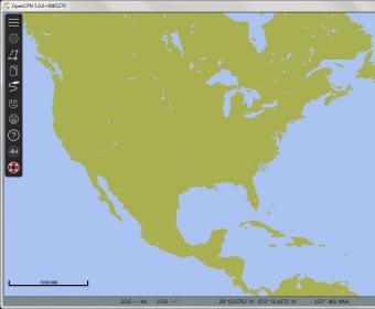
OpenCPN is a free software (GPLv2) project to create a concise chart plotter and navigation software, for use underway or as a planning tool. OpenCPN is developed by a team of active sailors using real world conditions for program testing and refinement.
Features
- BSBv3 raster and S57 ENC chart support.
- CM93 vector chart support, with per cell offset corrections.
- IHO S52 compliant display of S57 vector charts.
- "BSB4" and "nv-chart" support through plugins.
- Single-chart and Quilted display modes.
- North-up, Course-up and Chart-up display modes.
- Moving-map display mode.
- Route navigation with ship tracking functions.
- Waypoint navigation.
- Dashboard for configurable on-screen display of ship's NMEA data.
- NMEA 0183 GPS interface at selectable baud rate.
- OpenGL support for enhanced performance on modern hardware.
- gpsd library support.
- Autopilot output support.
- AIS input with full target tracking and collision alerting.
- AIS support for SART, DSC and GPSGate Buddies.
- Anchor watch/alarm functions.
- GRIB file input and display for weather forecasting.
- GPX Waypoint, Track and Route input and output file support.
- Route planning with tidal support.
- GPX Layers for annotation of charts.
- Tide and Current prediction and display by location.
- A growing number of plugins. Google Earth, World Magnetic Variation, Voyage Data Recorder, AIS -radar and a LogBook.
- Multi-language support.
Create and follow your routes while travelling with a high level of accuracy.
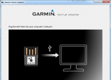
A program that allows you to update the firmware on your Garmin Vector device.


Comments (4)